
Benbrook Street-by-Street Walkthrough
Street-by-street research starts at one Benbrook address and builds outward through records keyed to the parcel. Tarrant Appraisal District gives the current assessed ownership record and the property account. CAID places that account on a map and exposes the surrounding parcel geography. The County Clerk's real-property index supplies the instrument trail. A directory, census, or voter lookup can add a time-specific person record, but none should be substituted for the others. A map label is not proof that a person lives at a parcel.
Record the search date with every result. Parcel ownership, mailing information, voter registration, and City files can change. If an address does not return a clean result, use a partial street query where the service supports it, try the account or georeference, and translate the address into a subdivision and lot or block. Older deeds may use only a legal description. Keep that description attached to the address so later records can be compared without relying on a familiar street name.
- Enter the address in TAD and save the account number, situs, current owner field, mailing field, legal description, subdivision, and instrument reference.
- Search the same address, owner name, or tax account in CAID, turn on Property, and click the correct parcel.
- Use the legal description or current owner as a grantee in the County Clerk official-records index, then identify the latest conveyance.
- Search the seller as a prior grantee and repeat the sequence when the question concerns the chain of ownership.
- Use a known-name voter lookup or a dated reverse directory only as the appropriate, time-limited household evidence.
Benbrook Parcel Cards by Street
Tarrant Appraisal District is the first address-keyed source for this street directory. A result screen offers property types for Residential, Commercial, Mineral, and Personal Property, an Enter Your Search field, Export, and result-count controls. Result rows can show Account #, Geo Reference, Property Address, Property City, Primary Owner Name, and Market Value. Detailed property cards can add current owner names, primary owner address, legal description, agent, state code or site class, subdivision, neighborhood code, map links, instrument, and year documents.
The key distinction is between the situs and the mailing address. A situs is the physical parcel location. The primary owner address is where assessment mail is sent. A Benbrook parcel can have an out-of-city mailing address, and a person receiving mail at a location may not own it. An exemption can be a useful tax clue, but it does not establish every current household member. Call TAD at 817-284-0024 for account questions if the public record needs clarification.
| TAD field | Street-search purpose | Limit |
|---|---|---|
| Property address | Identifies the situs parcel | Not a complete household listing |
| Primary owner name | Starts deed and owner research | Assessed ownership only |
| Account and georeference | Connects map and property card | Check the exact parcel |
| Legal description | Bridges address to plat and deed | May require lot and block research |
| Owner mailing address | Reads the tax-roll contact field | Can differ from the situs |
Note: The property card is an appraisal record, so it should not be presented as a live occupant list.
Benbrook CAID Street Map
The Tarrant County Comprehensive Address Information Directory, or CAID, is the map half of a Benbrook address search. It accepts Address, Owner Name, and Tax Account Number. Its available layers include Property, City Boundaries, ZIP Codes, Voting Precinct, Schools and School Districts, Flood and 2 Ft Contours, commissioner precincts, and other county data. Search an address, zoom to the parcel lines, and use the account or georeference to match the map result against the TAD card.
CAID is useful when a street has several similarly numbered parcels, when an address reaches a city edge, or when a reader needs the subdivision or lot context before opening a deed. It is not a legal survey. Benbrook's map guidance warns that boundaries are approximate and some layers turn on or off at different zoom levels. A shared driveway, drainage feature, or apparent gap must be checked against a recorded plat or County Clerk record rather than the map alone.
The Tarrant County CAID interactive map is the authoritative map entry point. Benbrook's Online Maps page also points to City map resources and the Real Dirt project map for construction, rezoning, subdivision, and improvement context.
Benbrook Deeds Behind Addresses
The County Clerk's Official Records Search turns a current parcel into a recorded ownership trail. Search the current owner as a grantee, use the property instrument number or legal description where available, and narrow by approximate recorded date. The portal's Real Property context offers Quick Search and Advanced Search, a recorded-date range, and Index Only or Index & Full Text OCR scope. Search terms can include grantor or grantee, subdivision, document type, or document number.
After locating the purchase deed, read the seller or grantor and search that name as a prior grantee. Continue through married names, initials, trusts, estates, companies, and each named role as needed. An old document can be indexed by subdivision, lot, or block instead of the modern street number. In that case, use the plat to translate the legal description, then compare the parcel and adjacent lots. A deed confirms a conveyance and parties to it; it does not create a continuous record of who occupied the address.
Tarrant County Official Records Search is the online deed index. The County Clerk's real-estate page also explains copies, plats, fee notices, and the property-fraud alert program.
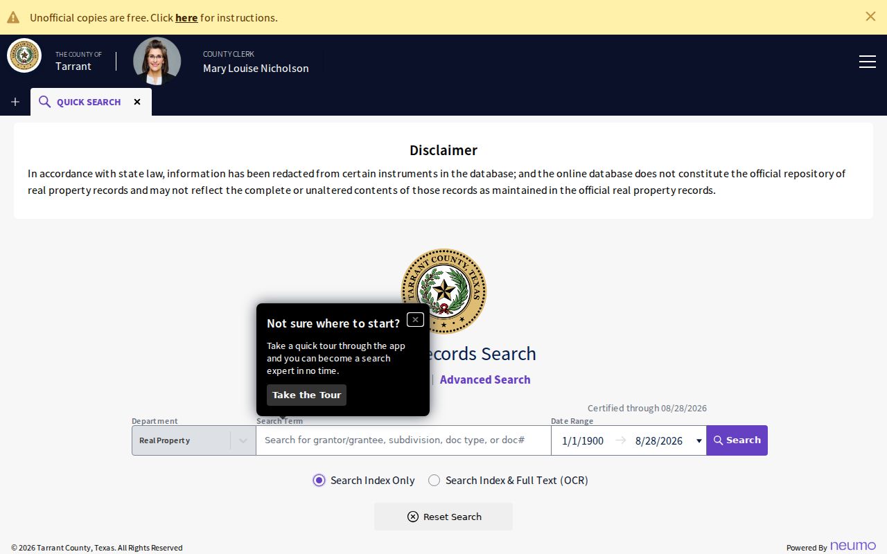
The official search screen shows the date, index, and OCR controls that connect a Benbrook address or legal description to a recorded deed trail.
Benbrook Street-Searchable Records
Address-keyed records answer different parts of a Benbrook street question. TAD supplies current assessed ownership and parcel facts. CAID adds location and layers. Official records establish conveyances, liens, plats, and legal descriptions. City permit, inspection, and code files can establish a project or observed issue at an address. A known voter lookup and reverse directory offer limited person evidence. Keep the record type in the notes so an owner, applicant, contact, and listed occupant are never treated as identical roles.
| Address record | What it can show | Benbrook access route | Fallback |
|---|---|---|---|
| TAD property card | Assessed owner, situs, mailing address, legal description | Public property search | Call TAD |
| CAID parcel map | Parcel, account, ZIP, district, and map context | Interactive GIS | County map help and TAD |
| Deed or plat | Parties, instrument, lot and block, conveyance date | County Clerk index or counter | Central Library, Archives, microfilm |
| Permit or inspection file | Project and inspection chronology, public parties | City system or request | City Secretary and archive |
| Code record | Address, inspection, notice, or resolution | Code Compliance or PIA | Detailed City request |
| Voter lookup | Known voter registration and precinct | County or state lookup | Tarrant Elections |
For a specific current address, follow the flow in order: address to parcel, parcel to account and legal description, legal description to recorded document, then a dated source for any person claim. The result is a record trail, not a bulk list of private households.
Benbrook Plats Translate Addresses
A plat is the bridge when a Benbrook street number is missing from an older deed. The City's subdivision process explains that preliminary plats lay out streets, lots, easements, and rights-of-way, while final plats legally create lots, easements, and dedications before recordation with Tarrant County. Search the County Clerk index by subdivision name, document type, date, or legal description. Then compare the lot and block with TAD and CAID before deciding that two records concern the same property.
Street names and city labels can change around annexation or development, while the subdivision description may remain the durable identifier. Benbrook's 2014 boundary adjustment with Fort Worth changed city-limit and ETJ geography. Research did not locate an official Benbrook street-renumbering list, so it is safer to bridge records through plats, landmarks, lot and block, and adjoining parcels than to infer a number change.
- Parcel
- A defined piece of land represented by an account, boundary, and legal description.
- Situs address
- The physical address or location used for the parcel, distinct from a mailing address.
- Plat
- A recorded map that creates or depicts lots, streets, easements, and rights-of-way.
- Criss-cross directory
- A directory section arranged by address, useful for a dated street lookup.
Benbrook Permits and Code Files
Permits and code records provide the change-over-time layer for a Benbrook street directory search. Building Permits and Inspections handles building, electrical, mechanical, plumbing, signs, zoning, and inspection work. Its online system can support permit applications, permit-status checks, payment, scheduling, cancellations, and inspection status, but it requires an account ID, password, and valid email. That system is not a complete public historical permit index.
For older files, request the permit number, plans, inspection history, final sign-offs, or complete address file from the City. The archive center also searches permit reports by keyword, archive category, time period, and date range. Code Compliance accepts a detailed location and description at 817-249-6078. A released record can date an inspection or identify a responsible party where public, but personal details and complaint material remain subject to Texas Public Information Act exceptions.
Benbrook Building Permits and Inspections provides the City system, while the City request route reaches material not found in the portal.
Note: A permit or code file documents a project or case, not a complete record of every person connected to an address.
Benbrook Street Directories in Print
Historical reverse or criss-cross directories are the address-to-occupant bridge for a past Benbrook street. The strongest local shelf is filed as Fort Worth Suburban. TSLAC lists Benbrook cross-references in irregular years from 1963 through 1993. Fort Worth directories offer a wider surrounding context beginning in 1877. Look in the street section, not only the alphabetical name section, and capture the exact street spelling, number, publication year, phone, spouse or occupation notation, and any directory key shown in that volume.
A directory is dated evidence. Search the year before and after because a publication and a move do not happen on the same day. Compare a street listing with the deed chain, tax roll, or census instead of assuming the listed person owned the parcel. The Fort Worth History Center and TSLAC offer the library route, while the Tarrant Archives can add historic maps, directories, school census, land research, and related collections. The full shelf is treated on the Benbrook city-directory page.
TSLAC's city-directory holdings identifies the Fort Worth Suburban cross-listing and its year runs.
Benbrook Street Records After 1876
The March 29, 1876 Tarrant County courthouse fire explains an important gap in early address research. Most pre-fire records were lost, although some probate or estate material survived and later transcriptions may exist. A missing early deed result is not proof that a family or parcel was absent. It may reflect a lost volume, a record held as microfilm, a handwritten index, or a legal description that must be searched instead of a modern street address.
Tarrant's documented grantor-grantee index for 1876 to 1920 and Fort Worth Library tax rolls for 1850 to 1981 are the main historical fallback. CountyFusion says historical document images continue to be converted and directs missing-record researchers to Central Library at 817-884-1069. Tarrant Archives has historic land ledgers from 1897 to 1908 and property ledgers from 1876 to 1917. Ask staff with the name, street or subdivision, legal description, and approximate year rather than repeating an unsuccessful web search.
Benbrook Street Labels and Boundaries
Benbrook addresses sit within more than one geography. US 377 or Benbrook Boulevard, I-20, Loop 820, Mary's Creek, Benbrook Lake, and subdivision plats shape the modern street grid. CAID layers can show city boundaries, ZIP Codes, schools, voting precincts, flood contours, and property lines. These layers help explain why a property near a city edge can have a Fort Worth postal label or appear in a different district without changing its physical location.
The 2014 Benbrook-Fort Worth boundary adjustment is another continuity warning. It changed city-limit and ETJ acreage, but it does not establish that a street was renumbered or that a deed changed hands. When an older record says Fort Worth, Fort Worth Suburban, rural Tarrant County, or Benbrook Station, compare its subdivision, lot, block, road landmark, and adjacent owners. This is more reliable than assuming a modern ZIP or city line applies to every older record.
Note: Research did not locate an official Benbrook renumbering list, so address continuity needs record-by-record confirmation.
Limits of Benbrook Street Directory
A street directory can identify public parcel and record connections, but it cannot verify every person who lives at an address. TAD identifies assessed ownership, not occupants. CAID identifies geography, not a household. Deeds show a transaction, not a continuous residence history. Directories place a listed person at an address in their publication year, not necessarily today. A voter lookup can confirm a known registration under the governing rules, but it is not an unrestricted street roster.
Texas also protects voter identifiers and addresses for protected people, birth and death records within statutory periods, sealed and expunged records, adoption records, victim information, and motor-vehicle personal data. Utility customer information is not a general public resident roll. For a City record, ask the custodian for the specific address, date range, and record type, and expect redactions or a refusal where the law requires them.